


Severe Thunderstorm Watch Guide 2025: late-summer/early-fall storm patterns are producing more frequent days with severe thunderstorm watches, severe thunderstorm warnings and (occasionally) tornado warnings across the Northeast. This step-by-step guide explains what each alert means, why the region sees them, how to track live radar and forecasts, and — most importantly — exactly what to do if your county is under a watch or a warning. All guidance is based on National Weather Service and emergency-management guidance and is current as of September 2025.
Topline definitions (simple, from the NWS)
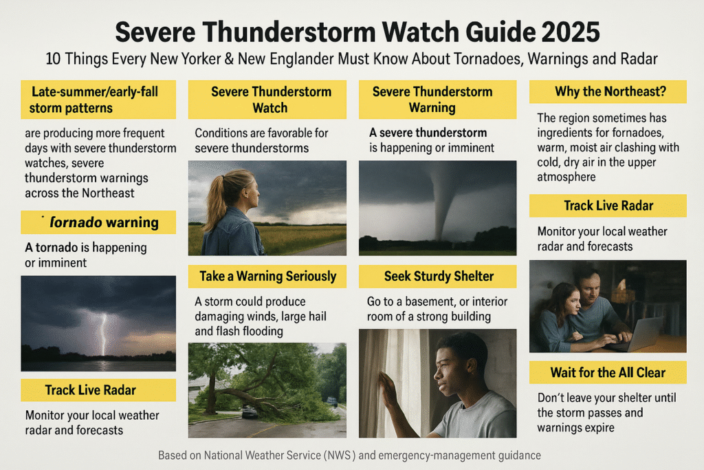
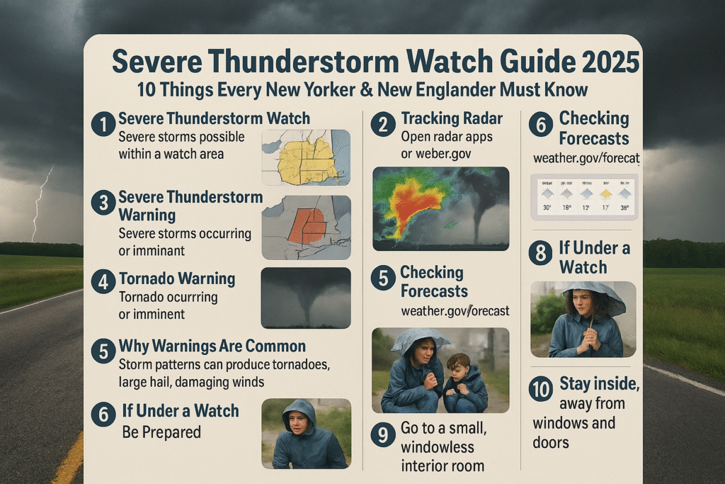
- Severe Thunderstorm Watch: Conditions are favorable for severe thunderstorms (large hail of ≥1″ and/or damaging winds ≥58 mph) in and close to the watch area. Be ready to act.
- Severe Thunderstorm Warning: A severe thunderstorm is occurring or imminent in the warned area — take protective action now.
- Tornado Watch: Conditions are favorable for tornado formation in the watch area — stay alert and have a plan.
- Tornado Warning: A tornado has been sighted or indicated by radar for the warned area — seek shelter immediately. The highest alert (a “Tornado Emergency”) is used when a violent tornado threatens life and catastrophic damage.
10 things you need to understand and do — step-by-step
1) Know the difference: Watch = prepare, Warning = act now
A watch covers a broad region for hours; a warning covers a smaller area for minutes. Treat a watch as a heads-up — get your plan and supplies ready. Treat a warning as immediate danger — move to safe shelter now.
2) Watch your local NWS office and briefings first
Your closest National Weather Service forecast office posts the most precise hazards, county-by-county warnings and local messages (for New York City the NWS New York (KOKX) office is the authoritative source). Bookmark or follow your local NWS office.
3) Use radar — it tells you where storms are now
Real-time radar helps you see storms and track movement. When a warning is issued, radar will often show strong rotation or high reflectivity (hail) in the warned cell. Check the NWS radar tile on your forecast office page or trusted apps that pull NWS/NOAA radar.
4) Understand the common threats: wind, hail, flash flooding, tornadoes
Severe storms in our region produce damaging straight-line winds, baseball-to-golf-ball hail and heavy downpours that cause urban flash flooding. Tornadoes are less common but possible, so never dismiss a tornado warning.
5) If a tornado warning is issued for your county — shelter immediately
Go to an interior room on the lowest floor (basement ideal), away from windows. Cover yourself with thick padding (mattress, heavy blankets) and protect your head. If you’re outdoors or in a vehicle, seek nearby sturdy shelter (do not shelter under an overpass).
6) During a severe thunderstorm warning — protect from wind and hail
Move indoors; secure loose outdoor items; stay away from windows and skylights (hail and wind-blown debris cause injuries). If power goes out, unplug sensitive electronics until service stabilizes.

7) If you’re under a watch, prepare a “go bag” and a safe place plan
Assemble basic emergency supplies (water, meds, flashlight, battery radio, phone charger) and pick a safe room. Keep pets and important documents accessible but protected. A short checklist and a practiced family plan save time when minutes matter.
8) Know the signs a tornado may be forming — act early if you see them
Large, persistent rotation in a cloud base, a loud continuous roar (like a freight train), or a low-lying funnel are signs of a tornado. If you see these, shelter immediately even if no warning has yet been posted.
9) Follow official channels — avoid rumor and social-media panic
Local TV/radio and the NWS produce authoritative updates. Social clips may show dramatic footage but can be old or mislocated. Wait for NWS confirmations before assuming a local tornado touched down at your location.
10) Why we’re seeing more active severe-weather days recently
Scientists and emergency managers note higher variability in storm frequency and intensity in recent years; heat, humidity and shifting jet-stream patterns change storm dynamics. That doesn’t mean every storm is “climate-driven,” but it does increase the importance of being prepared and informed.
How to track live forecasts for major local areas
- New York City / Long Island: NWS New York (KOKX) — current hazards, radar, written forecasts and local alerts. (National Weather Service, National Weather Service)
- Massachusetts / New England: follow your local NWS office (Boston area and regional offices) plus trusted local TV stations for live updates. Recent events in western Mass. have shown how fast a warning can be issued. (WCVB, NBC Boston)
- National outlooks: Storm Prediction Center and NWS national pages and 7–14 day outlooks provide the big picture on risk levels. (Climate Prediction Center)
Quick checklist (print or screenshot this before a storm)
- Phone charged + portable charger
- Flashlight + spare batteries
- 3 days’ water & essential meds
- Battery/hand-crank NOAA radio or app with NWS alerts
- Sturdy shoes, blankets, first-aid kit
- Family meeting spot & emergency contacts
(If you’re in a flood-prone basement area, identify a higher shelter in advance.) (TIME)
If you have to drive during storms — safety tips
- Avoid flooded roads (turn around, don’t drown).
- Pull off the road if winds make driving dangerous; park away from trees and power lines.
- If a tornado is visible and you cannot reach a building, leave the vehicle and shelter in a low, flat area — lie flat and protect your head. (Vehicles are unsafe in violent tornadoes.) (National Weather Service, TIME)
Sources & further reading (authoritative)
- National Weather Service — Understand Tornado Alerts (watch vs warning vs emergency). (National Weather Service)
- National Weather Service — Understand Severe Weather Alerts (Severe Thunderstorm Watch vs Warning). (National Weather Service)
- NWS Forecast Office — New York, NY (KOKX) — local hazards, radar and forecasts. (National Weather Service)
- NWS regional pages / local reporting — examples of recent tornado warnings and severe thunderstorm watches in Massachusetts and Connecticut (Sept 2025 examples). (WCVB, CT Insider)
- Time / FEMA guidance — preparedness and common sense checklists for tornado & severe-storm season. (TIME)
Final word
Watches give you time to prepare. Warnings demand immediate action. Keep your phone charged, follow your local NWS office, and have a practiced safe-room plan. Storms move fast in September — being ready, calm and decisive saves lives.
Disclaimer
This article summarizes National Weather Service guidance and reputable reporting available as of September 2025. It is for informational purposes only and should not replace official local emergency instructions. In an active warning, follow instructions from NWS, local emergency managers and first responders. Images used in this article are royalty‑free or licensed for commercial use and are provided here for illustrative purposes.