By TrenBuzz — Updated Oct 27, 2025. All times, tracks and official notices verified from the National Hurricane Center, Jamaica emergency authorities and major weather services.
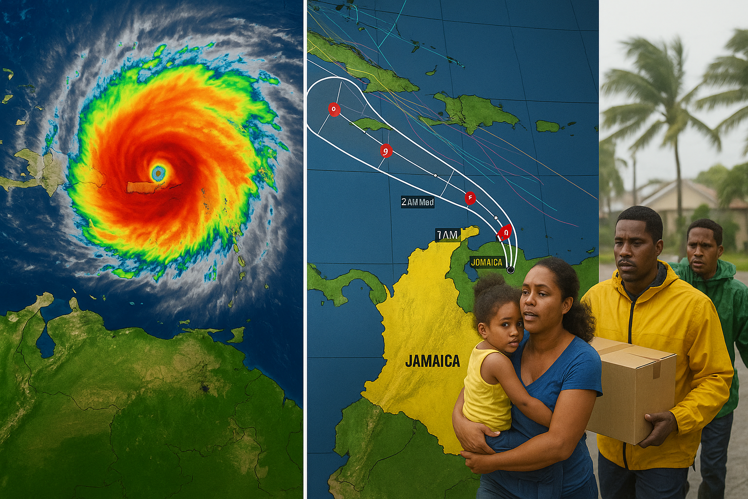
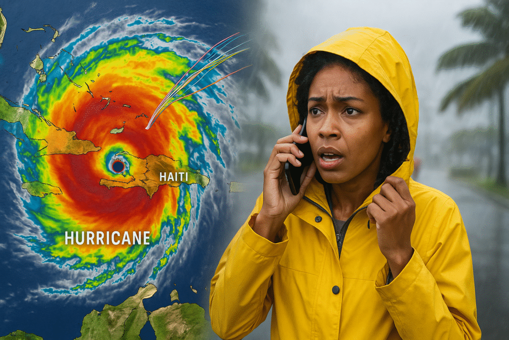
Hurricane Melissa Tracker, Jamaica Impact, Spaghetti Models: Hurricane Melissa rapidly intensified over the weekend and is a major hurricane as it approaches the northern Caribbean. The U.S. National Hurricane Center (NHC) currently lists Melissa as a Category 5 system with extreme winds and catastrophic rain potential for Jamaica, Haiti and parts of Cuba. Mandatory evacuations and full emergency activations are in effect in Jamaica; residents and travelers should follow official orders immediately.
1) Where is Hurricane Melissa now — the authoritative snapshot
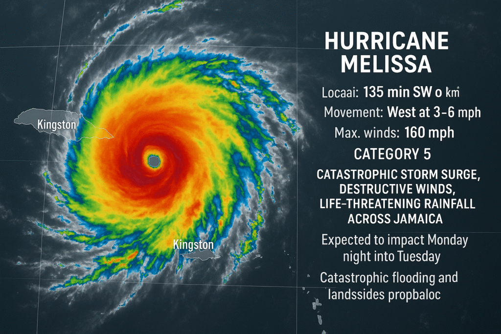
Hurricane Melissa Tracker, Jamaica Impact, Spaghetti Models: The National Hurricane Center’s latest advisory places Melissa roughly 135 miles (≈220 km) southwest of Kingston, Jamaica, moving slowly west at about 3–6 mph with maximum sustained winds near 160 mph (Category 5). The NHC warns of catastrophic storm surge, destructive winds and life-threatening rainfall across Jamaica. This is the baseline source for track and impact forecasts.
2) Will Melissa hit Jamaica — likely landfall timing and strength
Current forecast guidance and official advisories show Melissa approaching Jamaica with the highest impacts expected Monday night into Tuesday (Oct 27–28, 2025). Because the storm is slow-moving and intensifying, forecasters say catastrophic flooding and landslides are probable in southern and interior Jamaica. Expect the worst conditions near the time of closest approach and shortly thereafter. Follow the NHC advisories for the exact timing and any change to predicted landfall location.
3) How intense—and how much rain? (why slow storms are especially dangerous)
Melissa is forecast to drop huge rainfall totals—official warnings cite up to 30–40 inches in parts of Jamaica and southern Hispaniola through the event, with locally higher amounts possible depending on how slowly the center stalls. Slow forward speed lets heavy rain persist over the same watersheds, increasing the risk of catastrophic flash floods and landslides. If you are in flood- or landslide-prone areas, prepare to move to higher ground immediately.
4) Official Jamaican emergency actions — evacuation orders & shelters
The Government of Jamaica and the Office of Disaster Preparedness and Emergency Management (ODPEM) have issued mandatory evacuation orders for specified vulnerable communities and activated the National Emergency Operation Centre. Airports have closed and shelters opened across parishes. If you’re in a designated evacuation zone, follow the evacuation order now—do not wait for visible wind or rain to start.
5) What the spaghetti models are showing — how to interpret them
“Spaghetti models” are a collection of many computer-model forecast tracks plotted together. They show spread and uncertainty, not a single prediction. For Melissa: while many models cluster toward Jamaica and eastern Cuba, there’s model spread afterward (Bahamas, Turks & Caicos or out to sea). Use the NHC official cone (which blends models and expert guidance) as your primary decision tool — not a single spaghetti line. Spaghetti maps are useful to see uncertainty, but they are not a watch/warning.
6) Live trackers, webcams and how to use them safely
Useful live sources:
• National Hurricane Center (NHC) — official advisories, forecast cone, wind-probability graphics. This is the most authoritative tracker.
• The Weather Channel / Weather.com — rolling live updates, maps and radar overlays for situational awareness.
• AccuWeather and NOAA imagery — for satellite loops and technical graphics.
• Local ODPEM / Met Service Jamaica — local bulletins, evacuation lists and shelter details.
Note: Don’t rely on social media videos for safety decisions—use official agency notices and verified local emergency accounts. If you’re searching for “Kingston Jamaica live cam” or “Montego Bay weather cam,” expect many private streams; those are best for visuals only—not official guidance.
7) Will Melissa hit Florida or the U.S. mainland?
As of the latest advisories, Melissa’s immediate threat is the northern Caribbean (Jamaica, Haiti, Cuba). Long-range model spread exists beyond the Bahamas; the possibility of U.S. impacts (e.g., Florida or the southeastern U.S.) will depend on the storm’s post-Caribbean track and timing. It is too early to conclude U.S. landfall — U.S. interests should monitor NHC and NOAA updates daily. The NHC will issue official watches/warnings for the Bahamas and U.S. coastal areas if and when the threat increases.
8) Local conditions to watch in Jamaica — Kingston, Montego Bay & southern parishes
• Kingston & southeastern parishes: heavy rainfall, storm surge along low-lying coastlines and flash floods in urban drainage areas.
• Southern coastal communities (e.g., Old Harbour Bay, Rocky Point): mandatory evacuations are in place for many of these locations. Move inland if instructed.
• Montego Bay / north coast: may see tropical-storm/hurricane force gusts and heavy rains depending on the track; north-coast impacts tend to differ from the southern side but remain hazardous. Always follow ODPEM and Met Service updates.
9) Travel, airports and ports — what’s closing (airlines & ports)
Jamaican authorities have closed major airports and ports as a precaution. If you have travel plans to or from Jamaica in the next 72 hours, contact your airline and travel provider immediately—expect cancelations and rescheduling. Cruise itineraries and regional ferry services are likely suspended until the storm threat passes and port inspections clear operations.
10) Emergency preparedness checklist (what to do in the next 24 hours)
If you are in the storm’s path, do these now:
- Heed evacuation orders — go to assigned shelter or a sturdy location on higher ground.
- Assemble an emergency kit: water (1 gallon/person/day for 3–5 days), nonperishable food, flashlight, batteries, meds, cash, phone chargers, important documents in waterproof pack.
- Secure your home: bring indoors loose outdoor items, secure windows/doors, unplug sensitive electronics if advised.
- Plan communication: choose meeting spot, charge devices, keep NOAA/NHC, ODPEM and local radio tuned.
- Avoid floodwater: do not drive or walk through floodwaters; moving water is powerful and hazardous.
11) How to interpret NHC products (quick guide)
• Public Advisory: plain-language summary of storm position, intensity and watches/warnings. Use this first.
• Forecast Cone: shows probable path of the center — impacts often extend well outside the cone. Don’t assume safety just because you’re outside the cone.
• Wind and Storm Surge Probability Maps: show likelihood of specific hazards at locations—very useful for local decisions.
• Spaghetti / model suites: useful for seeing divergence; combine with NHC consensus, not as a replacement.
12) After the storm — first 72 hours recovery priorities
• Safety first: only return to evacuated areas when authorities say it is safe. Watch for downed power lines, contaminated water and unstable structures.
• Document damage: if safe, photograph damage for insurance claims. Keep records of expenses and communication with authorities.
• Water & sanitation: boil water advisories are common post-storm — follow local health guidance.
• Community support: if you’re able and outside the impact zone, coordinate donations with verified local charities and official relief channels.
FAQ — fast answers
Q: Where is the best live tracker for Melissa? — Use the National Hurricane Center (NHC) public advisories and graphics as your primary source.
Q: Are the Jamaica evacuation orders mandatory? — Yes, some are mandatory for specified high-risk communities; follow ODPEM/government orders now.
Q: Will Melissa become another historic hurricane? — It is already a major Category 4–5 and could cause historic damage depending on exact landfall location and speed. Prepare for the worst and hope for the best.